Wednesday, May 9, 2012

Charleston, SC–part 2

Magnolia Plantation and Gardens is an interesting place.  I like the house, but for me the gardens and the Swamp were better!!

Slave and workers cabins (not all original), they actually have them from various periods of time to show the differences.  I liked the tree in front of the cabins.  I can’t remember what type of tree it was.

The gardens were nice, but I missed the “peak” bloom time by a few weeks.  This garden is known for their camellias.  They introduced more than 150 types of camellias to the US in the mid to late 1800’s.  Not many were in bloom while I was there.

The best part for me was the swamp!!  I visited it twice.  Part of it is a rookery with several types of birds nesting.

Below are a bunch of pictures I took at the swamp--

Blue Heron -

Nesting Egret -

Tree with a lot of nest -  egrets, herons, anhingas… -

Alligator swimming in the swamp.  That’s Duckweed on top of the water.

The reason it’s called Duck Weed – The ducks love it!!  They eat a lot of it before migrating away for the summer. 

Little Green Heron -

Cherokee Rose -

One of many turtles -

Cousin It, nope!  It’s the back of a heron with his feather’s fluffed out.

Wild Iris, by the swamp-

I have many more pictures, but I had better stop. 

My next stop was Wilmington, SC. 

Charleston, SC

Yes, my clues were for Washington DC.  I was there for 2 weeks  and  left 2 days ago.  The weather was not bad while I was there (not too hot!). The crowds were bad the first week (some kids still on spring break), but the next week not too bad.  I’ll blog about this as soon as I catch up (4 or 5 more blogs)!

My next stop was Charleston, SC.  I was there at the end of March.

The first day I was there I went to Boone Hill Plantation.   Below is the view as you head into the Plantation.

The house -

The next day, I took a photo tour of Charleston.  I don’t typically do tours, but there is a lot to see in Charleston and I figured a photo tour might be interesting.  I don’t think my pictures are any better, but the leader did have a few interesting ideas. 

I liked the baskets.  They were made out of Sweetgrass by Gullah women. 

The tour leader showed us a puddle that she likes to use to take pictures.  Everyone in the tour (8 or 9 people) took pictures of this puddle.  I wondered what the folks walking by thought – those people must be crazy, taking pictures of a puddle!

She also lead us down some areas that I probably would not have found on my own.  We went down several interesting alleys.

Another example of one of her favorites, taking pictures through fences -

I ended up going back to downtown Charleston on my own a few days later.  I retraced some of the photo tour’s route and explored some on my own. 

One of my favorite places in Charleston was Magnolia Plantation.  I went there twice and took a lot of pictures.  I will post about these trips in my next blog.

Monday, May 7, 2012

Hunting Island State Park, SC

I visited Hunting Island State Park in mid-March.  To get to the state park, there is a very narrow bridge that you have to cross.  In a car it’s not too bad, but in an RV it was scary.  On my way there, I made it 1/2 way with nobody coming the other way.  But then I saw a tractor trailer!  Ugh!!  I made it, but I am glad that I didn’t have to drive it every day in my RV.

While I first got there, the tide was high in the mornings.  So for my walk I didn’t have much beach to walk on.  Below is a picture at one of it’s widest points that morning.

In the afternoons at low tide, there was so much beach that you needed a break just walking to the water!  Below I am sitting on the beach and you can barely make out the people walking along the water. 

On a few mornings, I would go the other way on the beach where it was a bit different.  Trees, grass, birds…

At the State Park, they had some great trails for hikers or bikers.  I biked a few of them and had a great time (read between the lines – good scenery and very few hills!).
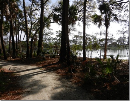
They have a nice boardwalk, which I biked to a few times and then went for a short walk.    One day I was there and saw some big white things hopping out of the grass.  I was trying to figure out what type of animal it was when they turned the corner and I was surprised to see the kayaks.  What I was seeing was the paddle coming above the grass.

At some point this area had some bad storms, I don’t know if it was a hurricane or bad wind.  But they have a lot of beach erosion.  On the bike ride there were several places where I saw a lot of trees down and a few destroyed cabins.    I believe the cabin below was on stilts (or whatever they are called) like the porch. 

The road with many of the cabins is closed due to the storm damage.

The campground is huge and has several camp hosts.  The host closest to me had their pets with them.  2 Dogs and a hawk.  I don’t think I have ever seen an RV’r with a hawk.

On the day I left, there was a great sunrise.
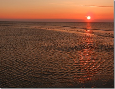
Next stop, Charleston, SC.


Below are 2 clues to my current location.  As you can tell from the various clues, I am in a location with a lot of things to do.

Friday, May 4, 2012

Kinards, SC / Prosperity, SC

Looking at the map before heading to Hunting Island State Park, I realized I was going to go very close to the town I was born in.  So I decided to stop for the night in Kinards, SC and take a quick trip to my hometown. 

I was born in Prosperity, SC.  It’s a very small town that made the news a while back when Clinton was running for President.  The following sign (or one like it) made it to newspapers and the TV news -

Clinton one way, prosperity the other!

While there I visited the cemetery where my grandparents are buried.  My grandparents lived next door to the cemetery and I have to admit as a kid we probably played around more than we should have around the graves.   The house in the background is where my grandparents lived.

I like to joke and say that I wasn’t born in a hospital.  I was born in a clinic.  The last time I was here I noticed it was still there, but closed and in bad shape.  So I decided to get a picture to show people the run down clinic I was born in. To my surprise this is what I found --

I guess saying I was born at a Dollar General will not be quite true, but that’s the spot where I was born!  At least I think this is where the clinic used to be!  It was just a few houses down from where we lived and I would tell people that my mom walked to the clinic when I was born.

Another clue to my current location.  This one may give it away!

Thursday, May 3, 2012

Mountain City, GA / Clayton, GA

The third clue to my current location is at the end of the blog.

A few weeks before my trip to Jacksonville, my mom told me that she had scheduled some minor surgery.  My original plans were to be in St. Mary’s, GA at that time and since that was fairly close to her (relatively speaking – I could have been on the other side of the country) I told her that I would stop by for a while to help her out.   As it turned out she had to postpone the surgery.

The only pictures I took the week I was there was of the bluebirds who had just returned to the campground in Mountain City.  The picture below was taken from inside my RV.

The third clue to my current location.  I don’t know if this will really help, but if you’ve been to where I visited yesterday, I’m sure you will remember this!  The next clue will be of more help.

From Clayton, I am headed to Hunting Island State park, with an overnight in a town very close to where I was born.

Jacksonville, FL–Hanna Park

Another clue to where I currently am is at the end of this blog.

In early March, the South East Lazy Daze group had their spring Get-together.  I had not been able to attend any of the gatherings in the last couple of years, but I made this one.  We had a great time. 

I didn’t take any pictures of the get together, just a few pictures of the beach and the walk to the beach.  Most mornings I walked the beach, below is one of many photos I took at sunrise.

There was a small boardwalk that connected the campground (once you’ve crossed the road) to the beach parking lot.  Some of the trees had a lot of red fungus.  I have seen it before and should know the real name, but all I can remember is one of it’s nicknames – bubblegum fungus.

Mystery Clue #2  (you may have to enlarge it to read it)-

Tuesday, May 1, 2012

St. George Island State Park and St. Joseph Peninsula State Park

Once again, I am way behind on my blog.  I am more than 2 months behind.   Sorry!!  At the end of this blog is a mystery picture.  It is a hint as to where I currently am.

I stayed at St. George for one week and then went to St. Joe for the following week at the end of February.  I fell in love with these 2 state parks more than 10 years ago and I still love them.  For the most part at both parks, I spent my days walking and biking.  At St. Joe, I enjoyed a bird watching tour. 

One of many reasons I love St. George -

Very few people!! 

A cloudy day on St. George-  

A Foggy morning on St. George -

A pelican diving for dinner -

I saw a few Portugese Man-o-wars on the beach one morning-

St. George has a trail/road not to far from the campground that leads to the end of the island.  This trail is mainly sand/dirt, with a few paved spots throughout.   I really enjoyed biking this trail, except for the wind!  On one side is the ocean and the other side is the bay and in many cases you can see both at the same time.

Below is a view from the trail. 

As mentioned, I went to St. Joe after St. George.  We had some great sunsets.

Everyone came out for the sunsets -

The picture below was taken from the boardwalk that leads from the road to the beach.  One side the beach, the other side the bay -

Great white sand dunes and the fog way off shore.  Within an hour or so, the fog had rolled in and it was foggy for the rest of the day!

The Mystery shot is below.  Any idea as to where I am?  I did block out some writing that could give away where I am visiting.