Saturday, July 27, 2013

Vernal, UT --- Part 2

I spent several hours at the McConkie Ranch in Vernal, admiring the hundreds of petroglyphs.  This Ranch is privately owned, but they allow visitors to hike the trails and view the Indian Etchings.  The Freemont Indians lived in this area from about 1 – 1200 A.D.  Some of the petroglyphs in this area have been called the best in the world.  Many of them are more elaborate than any I have ever seen. 

They do ask for a $2.00 donation to park.  Everything is on the honor system, including drinks they have in the refrigerator.  After visiting, many people have left comments and they tack these up in the welcome shed.

Most of the pictures are petroglyphs (etchings), but a few have paint on them so they may be considered petroglyphs and pictographs (paintings).

ver_mcc_p1

While I was there I only saw 3 other groups of people, below is a kid looking at some of the petroglyphs --

Many of these petroglyphs are life-size.

  A couple of web sites called the one above Hula Hoop Men.

The trail was a bit rough in a few very rocky areas, but considering it was the owners of the land who did all the work the trail was nice and the landscape was great.

In several web sites, it mentioned that there is some violence in the petroglyphs at this site.  I didn’t see much, other than some of the men seem to be holding heads, such as Big Foot above and some of them may be holding weapons.  Nobody knows for sure, but a few things I read suggested they might have been head hunters, while other people said that was not the case. 

There were many more petroglyphs on the first trail, but I had to limit the ones I posted.  I headed to the next trail, called the 3 Kings.  In 1980, the 3 Kings panel was on the cover of National Geographic.  There are many petroglyphs on the trail before the 3 Kings.

The trail along the cliff, along with the great scenery --

This looked like a lot of gears on the cliff -

The 3 Kings panel is very high up on a cliff and has some very detailed petroglyphs and/or petroglyphs --

A close-up of the above panel --

This was a great place to visit and I would go again if in the area.   If you are interested in looking at the detail of any of the above, don’t forget you can click on any of the photos to bring up a larger photo.

Friday, July 26, 2013

Vernal, UT (Dinosaur Land)–Part 1

I was in Vernal, UT June 17 - 23.  My original plans were to go before heading west to Salt Lake, but because I had a tire blow out on the RV, I decided to change plans and get tires before doing too much more driving. I wasn’t sure there would be enough to do for my one week stay, but as it turns out I could have stayed 2 weeks.

My first full day, I headed to Dinosaur National Monument.  I started my visit in an area that not too many people visit, Rainbow Park. The more than 12 miles of dirt roads probably stops many people from visiting this area. The main reason that I wanted to go to this area was to see the McKee Spring Petroglyphs.  Below is the short trail headed up to the cliffs where the petroglyphs are.

The cliff had several interesting panels of petroglyphs --


From this area, I headed back to the main and started my visit at the Quarry Visitor Center.   From there, you had to take a shuttle to the Quarry Exhibit hall.  You enter the exhibit area on the second floor where you see one side of the building is a huge slab of rock filled with dinosaur bones.  The theory behind this area is that this was an ancient river and a long drought killed many dinosaurs.  Then heavy rains came and floods drowned more dinosaurs and swept the dead dinosaurs into the river bottom.  As the water receded the bones were covered by sand and mud. 

Normally people don’t climb on the wall, but while I was there some workers or researchers were doing some work so you can get an idea as to the size of some of the bones.

On the bottom floor, there were a few bones that you were allowed to touch. 

A view of the exhibit hall and how it was built around the main layer of bones--

Instead of taking the shuttle back to the visitor center, I decided to hike the Fossil Discovery Trail back down.

While there were a few dinosaur fossils and some sea life fossils on the trail, I enjoyed the rocks and scenery more.  From here, I took the Auto Tour of the Tilted Rocks.

View from the road--

There were several stops that had petroglyphs--

This is Split Mountain, which is named because the Green River split it in half.  It was quite interesting.

The pictographs below include several lizards.  The lizards on the bottom look like they were made the same time as the other petroglyphs that I have been looking at, but the ones on top (just above the center of the photo) looked newer to me.  I did some research and there is a bit of controversy over these.  But most of what I read said they were still many hundreds of years old.  The others are about 1000 years old. 

At the end of the road is the Josie Morris Cabin area, which was interesting but I found the bird above more interesting than the log cabin and old sheds. 

All of the above was done in my first day and a half.  I will probably have 1 or 2 more blogs about my stay in Vernal.

Monday, July 22, 2013

North Salt Lake City - Part 2

One day, I headed into the mountains to the east of Salt Lake City.  I combined a couple of scenic drives for a nice day trip.  Parts of this drive were closed until just a few weeks ago due to the snow in the high elevation.  I hadn’t really made any plans on places to stop, I just figured I would stop if I saw something interesting.

I started on the Ogden River Scenic Drive, a pretty drive thru Ogden Canyon and into the mountains.  Then I made my way to Mirror Lake Scenic Drive (going thru a short stretch in Wyoming to get there).

I have almost gotten used to seeing cows and horses on the road in open range territory, but this was a first for me--

The sheep were on the road when I first saw them, but they quickly scrambled up this cliff. 

On the way up into the mountains, I started seeing a little snow on the ground and it got heavier the higher I went.  At the summit of Mirror Lake scenic drive, the elevation is 10,687 feet.

Pictures from the road --

My first stop in the mountains was at Butterfly lake.  I pulled off the road and took a few photos.

My next stop was Pass Lake, where I walked around for a few minutes. 

While walking around, I found a few flowers I found interesting.  I haven’t been able to identify it, but I think it is some type of lily.  It looks like glacier lily, but those typically nod (flower points down) and I think the petals on this one are thinner.  

Next, I headed to Mirror Lake.  The road to the lake had only been open a few days and you can see why--

The intersection where I turned into the parking lot was snow covered and I slid just a little bit.  I’m glad I don’t drive in snow often!!

I walked around for a bit here, but most of the trails were snow covered.

In both shots there is a canoe with 2 men.  I saw them rowing through some of the snow/ice and they told me it was like being in the Titanic.  They had caught 5 or 6 nice size fish.

After Mirror Lake, I thought that was probably the last of my scenic stops.  But I was very happy to see a sign for Provo Falls, as I wanted to do a bit more walking since I had been driving for a while. 

The first view -

I went down river and added a 3rd tier to the falls --

Going a bit further down stream, there were several more small falls and cascades.

This was a pretty waterfall and a great last stop before heading back to the city. 

From North Salt Lake City I headed to Vernal, Utah.  I’ll blog about that in a few days, I have to go through 100’s of pictures of petroglyphs first.

Sunday, July 21, 2013

North Salt Lake City

I was in North Salt Lake City during the middle of June for a couple of weeks.  Most of the time, I spent running errands (including getting new tires for my RV).  I picked an RV park close to town so I would be fairly close to stores and businesses.  When I saw that Pony Express RV Park was right on a biking/walking path, I decided it sounded good.  The sites were way too close together, as is typical in parks close to towns.  But I loved the path. 

nslc_bike_path

I walked and/or biked part of it almost every day (early in the morning while it was still cool).  The path is part of the 40 mile Jordan River Pathway in the Salt Lake City area.   I not only enjoyed walking and biking, but also watching nature – including birds and beavers.

In addition to the not so fun stuff, I visited Antelope Island State Park several times and one day I took a scenic drive into the mountains.  I enjoyed both very much.  It was quite hot while I was there, so I didn’t do much hiking in the state park – just a few short walks.  But I saw a lot while driving around the park.  Including this interesting site I saw on my first day at the park.

A deer on a truck!  Of course, it was a statue but it was kind of funny coming across this.

On a future visit, I took the picture below. 

The statue had been placed close to the visitor center, which is up on a hill on the island.  Behind the deer, you can see the lake and the bridge that leads to the island.

Antelope Island is particularly known for one mammal.  Anyone like to guess? 

Yep, Antelope Island is known for it’s Bison.  Apparently a long time ago some people were on the island and saw some Pronghorns, so the island became known as Antelope Island.  Later a few Bison were released on the island and they now have a large population of Bison.  A bit of education – a Pronghorn is not really an Antelope, but people do call them Pronghorn Antelopes.  A Bison is not really a buffalo, but people here call them buffaloes.  Buffaloes are found in Africa and south Asia. 

My first day I only saw a couple of Pronghorns, but on later visits I saw quite a few.  Below is one that found me just as curious as I found him and let me take several pictures before running off.

I saw many birds on the island, including a couple I had never seen before.

I saw quite a few Chukars while on the island.  This one had a nice view of the Great Salt Lake behind him.

The island had a lot of Meadowlarks.  While I had seen them before, I don’t think I had seen a Western Meadowlark this close.  They sang quite a bit for me.

A Loggerhead Shrike --

A Willet (I think) --

I saw a few Long-Billed Curlew which I had only seen once before --

I had seen Avocets before, but never as close as this.  On my first trip, I saw a few and got some so-so pictures.  So I hoped on my second trip I would see them again.

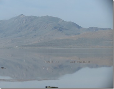
It’s a bit hard to see in the picture above, but just below the center of the picture you can see a row of birds in the Great Salt Lake.  Most of these are Avocets.  A close up of some of the row is below.

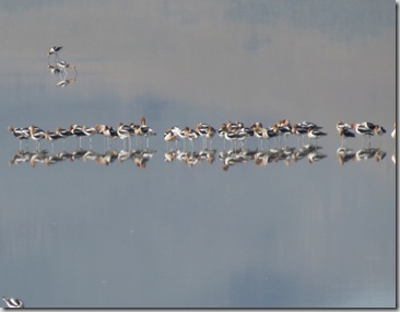
A not so good close up of 2 Avocets --

Of course, while here I had to at least put my foot in the Great Salt Lake.  So I parked and headed down to the beach.  This picture is on my way down to the beach.  There are a few people in the picture below (almost in the center), so you can tell it is a bit of a hike to get to the water.

My foot in the Great Salt Lake--

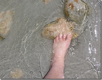
I don’t know if it was just the area I walked to or all of the Lake, but the sand/silt was extremely fine.  While trying to take this picture my foot kept getting covered with sand before I could take a picture.  I finally found these rocks that helped me get my foot shot.  Also while at the lake, I had to see how salty the water is.  I stuck my finger in the lake and tasted.  It was like I had put my finger in water and then in a bowl of salt -- it was very, very salty.  It is from 2 to 7 times saltier than the ocean.  Please don’t tell me what other nasty things were in that taste, I decided to tell myself that the salt killed everything else!!

While I was there, Salt Lake City’s Farmers Market opened up. I enjoy going to local farmer’s market and craft shows.   It supposedly opened at 8:00, but I was told to get there early to find a place to park.  I got there about 7:45 and most vendor were already open and it was busy.  The picture below was taken about 8:30.  I am glad I got there early, I would not have wanted to be there a couple of hours later when it was busier.

I’ll blog about my scenic drive in a few days!!  It was great.