Tuesday, June 12, 2012

Watkins Glen State Park, NY

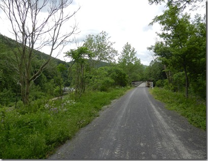
When I used to think of New York, I thought of New York City.  I had always heard that upstate New York was beautiful, but still the image the city is what came to my mind.  That was in the past, now I will think of scenes like this ---

The above was taken on the  Buttermilk Falls Gorge trail.  More on this hike later.

My visit started with rain.  So, I went to Corning and visited the Glass Museum.   The modern gallery had some interesting items made of glass. 

They also had displays of items made of glass a long time ago. The  items below were made between 1440 BC and 1085 BC. 

I watched a glass blowing demonstration (the pictures didn’t turn out too well) and a flame thrower demo.

The guy above made a dog out of glass in just a few minutes. 

The next day, I went to Buttermilk Falls State Park.  I hiked the gorge trail up the gorge and the rim trail back down.  I would have to guess that it is at least 300 – 400 stairs up the gorge, but it was well worth it!!

The first falls is right at the parking lot, so even those not hiking can see a great waterfall.  The trail was cut into the shale and limestone.


That same day, I visited Taughannock Falls State Park.  The first picture was taken from an overlook.  The second picture was taken from the end of the Gorge Trail.  This trail was level, which I needed after hiking Buttermilk Gorge.

I woke up the next morning, planning on getting to the entrance to Watkins Glen Gorge Trail around 8:00.  As I was pulling into the parking lot, a park volunteer followed me to my parking spot and pointed out that I had a tire almost flat.  I went to a close gas station and filled it up with air and went back to the park.  There I looked at the tire and could hear the air coming out.  So I quickly found a place to change the tire for me.  That put me a couple of hours late for my hike, but I headed on.

The Watkins Glen Gorge Trail has more than 800 steps and has several warning signs about the difficulty of the trail.  I headed on, the pictures I had seen were too beautiful to let a few steps stop me!  Again the trail is cut into the rocks.  Rocks and waterfalls, what more could I want in a trail!!

The entrance to the Gorge is a tunnel., one of several on the trail.

Did I mention the many stairs?  It actually wasn’t too bad because it was so beautiful I was stopping to admire and/or take pictures all the time.

The above waterfall was one of a couple that you walked under.  The picture was taken coming out of one of the tunnels.


Both Watkins Glen Gorge Trail and Buttermilk Gorge Trail were too beautiful for words.  My pictures do not do this area justice.  If you like waterfalls, I would strongly suggest adding this area to your list of places to visit. When I have more time I will come back to the Finger Lakes area in New York.   Much better pictures and information on these falls and others in New York can be found at www.nyfalls.com 

From here I headed to Letchworth State Park, which is where I currently am.  I’ll blog about this trip in a few days!

Friday, June 8, 2012

Wellsboro, PA

Wellsboro, PA is in Tioga county, which is known for the Pennsylvania Grand Canyon.  There seem to be a lot of “Grand Canyons”!  I was looking forward to the canyon, but particularly the Pine Creek Rail Trail that goes through the Canyon.  I had read about the trail, which is a 62 mile trail through the Pine Creek Gorge and beyond. 

View of the gorge from an overlook at Leonard Harrison State Park.  You can just make out the trail beside the river in the picture below--

Since the trail was at one time a railroad track, it only has about a 2% grade so the biking was fairly easy.  I ended up riding 3 different days.  The first day was more a test of the trail and my knee.  I rode about 6 miles that day (3 miles down and 3 miles back).  My second day I rode about 23 miles all one direction.  Pine Creek Outfitters shuttled my car to one of the parking spots 21 miles down the gorge.  That meant no backtracking!  My third ride, I rode 11.99 miles (I know I should have ridden my bike around my car to get that extra 0.01 miles).  The pictures below are a mix of all 3 rides.

I started at the Ansonia Trailhead the day I went 23 miles and at Darling Run Trailhead the other 2 times (about 5 miles from my campground). At the first part of the trail from these 2 trailheads they allow horses on the trail.  That is only allowed for a small section of this trail.  The bike riding side of the trail (left side) was a very hard packed dirt trail.  The horse side was looser dirt and gravel.

It is very hard to tell, but there are 2 fishermen in the creek.  I wanted to post this so you could tell the size of the creek.  It was one of the widest creeks I have ever seen!

On one of my trips, I saw some kayakers (in picture below).

View from trail where Marsh Creek and Pine Creek merge.

As I said they allow horses.  This was taken at the Ansonia Trailhead.  I also saw some horses pulling a covered wagon (for those who don’t want to bike or walk the trail), but that picture didn’t turn out.

This duck seemed to be swimming away from me, even though I was quite a distance from her, so the picture is not great.  Some of the baby ducks were on her back, while others appeared to be swimming.

This waterfall was just beside the trail.  It is just beside the Turkey Path which is a popular (but steep) trail in the Leonard Harrison State Park. 

This bridge was just before Rattlesnake Rock, it is just beyond the gorge.  It still had mountains around it, but was much more open than through the gorge.  By the way, they are warning signs about the rattlesnakes in the area, but I did not see any.  I did see a water snake.  I also saw several deer and a bald eagle.  

This bike ride is one of my favorite rides ever.  The scenery was great and having my car at the end of the ride worked out well.

I also did a short hike in Leonard Harrison State Park (which was only about a mile from my campground) and saw a deer who seemed to be as curious about me as I was about him.  He was only 20 – 25 feet away from me.

One morning I went to the Marsh Creek Wetlands, also called “the Muck”.  I don’t know who owns the area, but the trail and observation blind are a project of the Audubon Society of Tioga and Potter counties.  I had hoped to see a Least Bittern, but the day I went I saw few birds.  I think I got there a bit late as the person who was leaving just as I got there recorded in the log that he say 15 to 20 different type of birds.  He was there very early – 5:30 am to 8:00 am.  I was there 8:00 a.m. to 8:15 a.m.    I ‘m really not patient enough to be a good bird watcher.   I have a few pictures of a green heron that I saw while there.  But below are my favorite pictures I took there.  The first is the other visitor who was on the trail while I headed towards the blind.

The turtle was at least a foot long and quickly retracted his head into his shell when he heard me. 

Since I didn’t get many pictures of birds, I took the picture above from inside the blind.

It rained a bit while I was in Wellsboro, but as you can tell I managed several great trips!  This is my last stop in Pennsylvania, I head to New York next.

Sunday, June 3, 2012

Sheffield, PA

From Cook Forest State Park, I headed to Sheffield, PA.  This town is “the Heart of the Allegheny National Forest”.  My campground was next door to a trail in the national forest, which was one of the reasons I decided to stay at Whispering Winds Campground.

My knee still wasn’t great, so I stuck to easy and moderate hikes. My first hike was Rimrock Trail.  I ended up not doing the entire thing because it was steep and rocky in some sections.  I found out later that the other end was not as bad, so I should have stuck it out.

Headed down to the trailhead—(for those who read my blog regularly you can see why I would really like this trail – Big rocks!)

View from Rimrock Overlook-

Start of trailhead, headed through several big rocks -

Another hike I did was Hearts Content Trail (and a bit of the cross country skiing trail in the area).  This area is known for it’s old growth trees.

Not too far from the campground was Bradford, PA.  I went there a couple of times.  I was told by a couple of people to visit the Zippo museum.  It didn’t really sound like something I would like, but one day while there I went because it was free and I needed a place to use the restroom!

The flag is made of 3393 zippo lighters.  I was only in the museum about 10 minutes.  By the way, nice clean restrooms!!!

On that same day, I went to Kinzua Bridge State Park.  This park is known for the Kinzua Sky Walk.  This bridge was built in 1900 for trains.  Since 1963, it became the centerpiece of the State Park.  In July 2003, a tornado came through and 11 of the towers holding the bridge up were twisted and fell to the valley floor.  You can make out the fallen towers to the right of the bridge below.

The walk out to the end of the bridge.shef_kinzua_bridge_start

At the end of the bridge you can walk on and look through the glass floor.

The view from the bridge -

Another easy trail was Marilla Bridges trail.  The trail circled a small reservoir.

I saw Buzzard Swamp Trail on the map and knew I had to visit.  I learned that the area was a good area for bird watching.   The day I went it ended up getting stormy, so I only walked about 4 miles. 

I didn’t see any buzzards, but did see quite a few of these.  It may be a Tree Swallow, but I’m not sure Tree Swallows are this blue.  It was fun watching these birds as they were like acrobats. 

I didn’t know this area had oil.  From what I understand they still get oil, but natural gas is the big thing now.  The area I went to next is in the middle of natural gas boom.

It was funny to be on a scenic drive and see these.

During the Memorial day weekend, my campground had several events.  The only one I participated in was the Duck Race.  For a small donation, you got a duck with a number on it.  My duck was number 6.

Many ducks would get stuck on rocks or behind sticks, the people behind the ducks would get them unstuck.  Below is a duck going over the “waterfall” that was behind my RV.

Everyone lined up at the finish line.

There were about 50 ducks and I never saw duck 6 (other than when I made my contribution), who knows if he even made it to the finish line!   During the week this campground was fairly empty, but full for the long weekend. 

This was the first campground where my Electrical Management System came up with a very low power and cut the power to my RV.  I had noticed earlier in the week that the power was a bit low, but it was ok.  Once everyone got there for the weekend and were using their air conditioners (it was rather warm), my power dropped to between 108 and 105.  I cut my air off and the next day told the owners.  I went hiking and when I got back I noticed that my EMS system had cut the power to my RV.  I checked the electrical pole and saw the power was down to 98.  A little later the owner had an electrician working on it and eventually got me more power.  Fortunately for me, the electrician was at the campground for the weekend and seemed to help the owner out occasionally.  I haven’t found too many times when my EMS system found anything wrong, but the 3 or 4 times it has I was very glad that I had installed this system.  

Believe it or not, I am caught up with my blogs.  Barely, but I am.  My goal has always been to write my blog at the stop after the one I am writing about.  I am currently at Wellsboro, PA which is the stop after Sheffield.  But I am leaving today, so while caught up, I only made it by a few hours as I am leaving later this morning!!