Sunday, June 7, 2015
Cow Head, Newfoundland
In Cow Head I stayed at Seabreeze B&B/RV park. The view was great -
The day I arrived, I hiked the Lighthouse trail in Cow Head Peninsula.
A view from one of the lookouts -
Spring Beach was my favorite part of this hike --
Newfoundland has many fishing villages and is known for it’s scenic villages and houses on hills overlooking the ocean or gulf. This was my first sighting of colorful fishing buildings.
Since I plan on returning to Gros Morne in a few weeks, I decided on my second day to head North to Port Au Choix National Historic site. While several cultures (Eskimos and Indians) have lived here, I was more interested in the natural beauty and the lighthouse. I ended up just hiking 2 miles as I spent a lot of time goofing around on the beach (first picture below), looking at and admiring the scenery and checking out the plants.
I spent most of my time on the Port Richie trail. It is basically along the coast on limestone rock that is very barren. The rocks mark the path I hiked.
In a few places it was very boggy and they had these boardwalks placed in most of the wet areas.
Some of the plants I found interesting are below. Both of the flowers below are very small, less than the size of my pinky fingernail. The plant between the flower is very small also, with the larger of the reddish brown part being maybe thumb nail size.
Note - I am having Live Writer problems again so am posting through blogger.com. It may be my internet though as I am using the wifi at the campground and it occasionally comes up and instead of connected says limited.
Wednesday, June 3, 2015
The start of my Newfoundland, Canada Trip--
I made it, I have talked about this for several years and I am finally in Newfoundland, Canada!!! I will be here until the middle of August. I was advised by 2 people to not head over to the island of Newfoundland until July because in June it can still be cold. But I didn’t listen and I am here. On my first morning, it was 32 degrees (or I should say 0). It’s going to take time to get used to Celsius instead of Fahrenheit.
I have been in Newfoundland 2 full days and I have already seen whales, Moose and Caribou!
I caught the Ferry to Newfoundland in North Sydney, Nova Scotia. The website says the ride is 6 – 8 hours to Port aux Basques, Newfoundland.
In line for the ferry --
It has 2 entrances into the ferry. The 18-wheeler on the bridge is headed into the deck above mine.
It’s just about my turn to drive my RV and tow car into the ferry --
From the picture above, the ferry doesn’t look so big. But once inside there were 6 – 7 rows of trucks and cars. So many that when it came time to get back into our vehicles I couldn’t find my RV due to all the rows of 18-wheelers that were surrounding my RV.
They really park them close. I had to put my camera down, because my side mirror was within an inch or 2 of the truck beside me
Inside the ferry, there were very comfortable seats, a restaurant, a coffee/snack bar and gift shop. They also have cabins, but for 6 hours I didn’t need that. You are not allowed to stay in your vehicle or even go back down to it during the trip.
We saw 15 – 20 whales. They were very far away, but it was a great start to this trip.
One of my first views of Newfoundland. You can barely make out a small lighthouse and of course, you can see there is still snow on the mountains.
Once on the road, I got a welcome (blue sign) and the small sign behind it warns of moose!
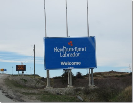
My first night I only drove for 30 minutes or so up to Doyles. I stayed at the Grand Codroy RV Park for the night. I will be back here in September to tour the area.
From Doyles, I am making my way up to St. Anthony’s for the Iceberg festival making a 2 night stop in Cow Head on the way(which is where I currently am).
I’ll post in a day or 2 about my time in Cow Head.
New Brunswick, Nova Scotia --
From Maine, I headed into Canada. I was a bit concerned about the border crossing having read a couple of horror stories (border agents going through the RV), but most people said they went through with no problem other than the wait at the border. So I get to the border check point--
There is nobody in line! The plan was while waiting in line to dig my passport out. Oh well!
Speed limit –Wow that’s fast -
Ok, that’s in kilometers. Which is about 68 mph! I am going to have to get used to this.
I am basically just passing through New Brunswick and Nova Scotia, but I stayed 2 nights in St. John, New Brunswick. The plan was to find Canadian Money. I had read several things and it seemed the best way was just to use an ATM. So I found one and it worked. I stayed at Rockwood Park in St. John, which is an ok RV park. It’s just a gravel lot but in downtown St. John and has several walking trails.
From St. John, I headed to Nova Scotia, with one stop in Glenholme, NS and then on to Little Bras D’Or (I don’t know how that is pronounced, but if it is the way I read it, I should have stayed up the road in Big Bras D’Or).
While on the road, I have been enjoying their signs. I have to think about some of them and few I am not sure yet what they mean.
It took me a few seconds, but I realized this is slippery when freezing.
The following are not great pictures because they were taken while driving, but I had fun trying to figure these out.
I haven’t figured out what the hand holding the pottery is, probably crafts. But later I saw a spinning wheel, so maybe it really means there is a pottery at that exit. On the second one, I am guessing the grapes mean a winery. I wasn’t sure what the 5th one on that same sign meant, but I have learned that’s the sign for Parks Canada. On the last one, I am still not sure what the key is. I am guessing that the @ means there is internet access somewhere?? One of my favorites was a picture similar to the one with person sleeping under a roof, with an egg in an egg cup beside it. I figured out that meant there was a Bed and Breakfast at that exit. Who knows, but it kept me entertained while driving down the road.
Thursday, May 28, 2015
Bar Harbor and Acadia National Park - part 2
While in Bar Harbor, I went for a bike ride on some of the carriage roads that John D. Rockefeller Jr started in 1913. These roads are about 10 feet wide, but only walkers/runners, bikers and horses (with or without carriages) are allowed on these roads. They are hillier than I am used to since most of my bike rides are on rail trails. I ended up riding about 8 miles, with most of that on a trail that goes around Witch Hole Pond (which is supposed to be the easiest trail) and a short part of the Eagle Lake trail. I had hoped to ride more, but the hills were tougher than I thought. The following day, I could feel it! Below are pictures of the carriage road trails and views from them.
I am guessing that the picture below is why it is called Witch Hole Pond?? Dead trees??
One of many interesting bridges on the carriage trails--
Another trail I hiked was Valley Trail (which was at the same area as Beech Cliffs that I wrote about in part 1). When I talked with a ranger, he would not tell me why he thought I should hike it. He just wrote "WOW" on the map he was writing on for me. I loved it!
You can see the high rock cliffs in the background of the picture below.
That may be too many rocks ,ferns and moss for some of you but I loved it and could not decide which pictures to post. Believe me, I have many more!!
One day, I drove up Cadillac Mountain and walked around up top for a while.
I also visited Bass Harbor Head Lighthouse, where if the sign is correct a Coast Guard Family still lives in it. It was hard to get a decent picture of it. You can see the red light in the lighthouse, it was foggy that day, so I waited for the light to come on to take the picture
From Bar Harbor, I headed into Canada where I am sitting in my RV because it is extremely foggy in St. John, New Brunswick. So foggy that I got a bit wet just walking outside for a couple of minutes.
Bar Harbor and Acadia National Park - Part 1
Can you believe it?? I am actually not behind in my blogging. It has always been my plan to post the blog as soon as I leave the area and I just left Bar Harbor yesterday!
I was in Bar Harbor May 20 – 27 and had a great time. The weather was a bit cold and a few times rainy and/or foggy, but I would rather it be cold than hot.
As my few readers know I love rocks and I love water, especially the coast. So the Maine coast was great! Below are some shots that I took while rock hopping on some stops along the loop road in Acadia National park.
A couple of shots of me relaxing and enjoying the view --
I have found the panoramic shots look better if you click on them to enlarge it.
I hiked several trails while there. One of my favorites was Beech Cliffs. It is one of the shorter trails, but I loved it so much I did it twice. The trail starts of heading up a hill in a wooded area and then I came to the view in the first picture below. I knew I was going to like it at first sight. Then up and over the rocks and wow!
The picture below shows Echo Lake below the cliffs and off in a distant is the Gulf of Maine.
The shot below is looking the other way, with a view of the trail, which climbs the rocks in the upper left corner and Echo lake down below.
The trail was great, it included a bit of rock climbing and some fantastic views!
Another short trail I hiked was Wonderland trail. It lead to the shore in an area known for it’s tide pools. I enjoyed it and was hoping to find a sea star, but didn’t.
While there, I stayed at Mt. Desert Narrows RV Park. It is a private park that is ok. The restrooms were a bit dingy (old, but clean) and for wi-fi I had to walk up to the community building. But the view I had made up for everything. The campground was located along a basin (I think it’s Thompson cove, but I can’t find that map!) in the gulf. I enjoyed watching it at different times as the tide changed. The first picture was taken with my phone on my last night there. (so no fancy camera to change the colors). The second is a panoramic shot taken at close to high tide. At low tide most of the area in the photo was dry (well muddy).
I took so many pictures I will post the others in part 2.


